
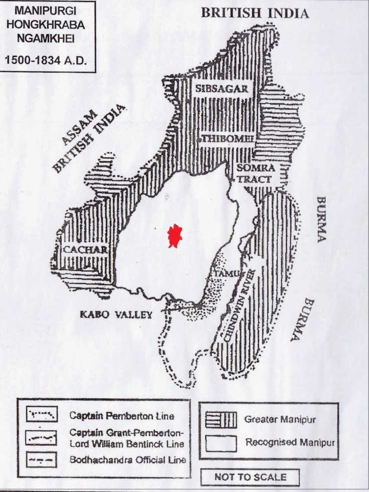
The territory of Meetei Leibak consists of three valleys – the Imphal Valley, the Kabaw valley and the Barak valley. The kingdom expands up to south Yunan province of China.
Before the arrival of British in the Eastern frontier of Bengal, the Meetei Kingdom has reached its highest suzerainty in the region. During the period from 16th Century to the middle of Eighteen Century, Meetei Leibak was a powerful Kingdom in the East.
Meetei controlled an area that extended from the Nou Kian river of Tibet in the North to Aracan in the South; from the Garo Hills and Bengal in the West to the Yunan province of China in the east. (for reference see An accurate map of Hindoostan or India,by Mathew Carey, Series no 57, page 53, published in Carey’s General Atlas, Philadelphia, 1814)
The territorial integrity of Meetei Leibak (now Manipur) has been powerfully established for more than 500 years, beginning from 1400 AD to 1900 AD. Henry Yule’s Map of Manipur in 1500 AD till James Johnstone’s map in 1896 shows the powerful Meetei Leibak.
These Maps have been used and recognised by other Nations in their official records and documentations. The maps prepared by few separatist movement like the Southern Nagalim and Kuki homeland is a mockery to International communities.
The territory of Meetei Leibak was extended up to the bank of Brahmaputra river in Assam. In the Chittagong Treaty of September 14, 1762, Manipur Maharaja Gourashyam would sell 500 pieces of Meckley ( another name of Manipur) gold rupees @ Rs 12 (silver) per piece annually to the British out of the gold mines of Manipur at the bank of Brahmaputra or elsewhere within the territory of Manipur.
When Burmese (Awa) invaded the land during the reign of King Paikhomba in 1693, the Meetei soldier fought the battle on the bank of Ningthi river (now in Myanmar). Two Meetei soldiers were died in the battle and successful in repelling the invading Awa. If Meetei land as claimed by today’s half brain historians as Imphal Valley only, this battle could be fought near Kangjeibung in the Imphal district or khongjom in Thoubal district.
Department of Hill Affairs (Haomacha Loisang) was establish in Meetei Kingdom during the reign of King Irengba (984-1074). If Meetei land, as claimed by some history and political students of JNU or DU belong to Imphal Valley only, what was the point of establishing such Hill Affairs Department some 1000 years ago when terms like Nagas and Kukis were not created in the political history of the World?
Meetei kings, on several occasions went for military expeditions in the hills. Don’t confuse this as war or invasion to a foreign land. Meetei kings have many feudal chief as well as tributary chiefs who resides in the hills of Meetei Kingdom. The word invasion in the hills is a new term coined by self styled researchers to show territory of Meetei Leibak confined in the valley.
What was the necessary of military expeditions against his own subjects? Those were to prevent raids by one village to another village; to collect tributaries from those chiefs who tried to go rebel against the Kings; to subjugate the rebellious chiefs or khullakpas; to reassert supremacy of the Meetei Kingdom and to impose Lanlup (tributaries paid to Meetei King by defeated Chiefs of Hills) systems.
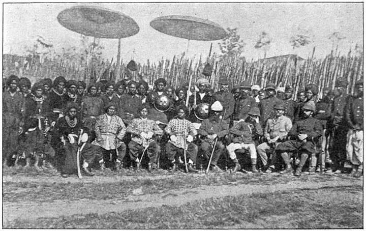
In 1833, Meetei Ningthou Gambhir Singh conquered Thibomei (present day Kohima). He stayed there for a month. The Angami tribes gave 100 bullocks to him. In exchange for the release of captives, they gave another 100 bullocks. During his stay in Thibomei, the Ngamai khullen and Ngamai khunou villagers came to Meetei Ningthou and declared submission, giving 400 bullocks, elephant tusk and 200 baskets of teel seeds.
Meetei Ningthou Gambhir Singh put his footprints sculptured on a stone in token of conquest in Thibomei on 10th February 1833. This stone erection ceremony was performed with the Naga villagers. On this day, Mera Mechamai, Tonloi, Chamai, Pettamai Khunou and Khullen, Uttu Washamai, Wahamai, Khisami villagers gave 600 heads of Cattle as tributes.
As per the British records, the hills areas of Meetei Leibak were looked after by General Thangal Singh and General Balaram Singh. General Thangal look after the area stretching from the Cachar road and villages along it, the Thibomei (Kohima) road as far as the Thoubal and beyond. General Balaram Singh controls the Kukis at the Southern end of the valley and the whole of hills west of the valley. The north eastern corner including the Somrat basin and the Kabaw Valley.
In 1786 AD, Maharaja Jai Singh went to Teepai and settled the boundary of Tripura and Manipur. He also confirmed the boundary which was settled by Maharaja Garibniwaz. Again in 1871 AD, General Nuthal went to Chibu Valley (in present day Mizoram) where some 23 men came from Poiboi, Lengkhum, Saileth and Damboon, acknowledging themselves before General Thangal, General Balaram and General Nuthal himself to be the subject of Maharaja Jai Singh of Manipur.
They promised that they would not commit any wrong againts the Maharaja of Manipur. This shows major portion of present day Mizoram was under the control of Meetei king. Where is the question of Churachandpur, an outside region of Meetei Leibak? (Source- W.F. Trotter, Political Agent of Manipur).
At Chibu, the Meetei kept a stone slab bearing king Chandrakirti’s footprint which was engraved at the house of Chibu’s chief. Chandrakirti occupied 112 villages of the present Mizoram and he also brought 1126 men as war captives to Imphal.
Maharaj Chandrakirti took measures to protect the Kukis, who were being tormented and slaughtered by the Lushais from present-day Mizoram. In his efforts to shield them, he provided arms to the Kukis and settled them in the south of Moirang, which is now known as Churachandpur. This strategic move was aimed at halting the raids by the Sukhtes before their subjugation.
After Meetei King got alliance with the British, the word “Kuki” was created. As per the records of “Khul Koun Ho Thusim”, the Meetei King gave the duties of controlling hills of Meetei Kingdom to four feudal chiefs, namely Shairing Chothe, Sokhojam Singson, Lamhao and Paosuol. These feudal chiefs went to collect taxes and suppress rebellious chiefs who tried to work against the Meetei king and controlled the affairs of newly created Kuki hills.
Later in 1921, the present town named as Churachandpur came up. The place was previously known as Songpi. There was a Sub Divison office in Songpi area. It was renamed into Churachandpur to honour the Chief Guest, Maharaj Churachand in a welcome function of Labour Corps who were sent to Europe.
In the newly established Churachandpur Sub Division (erstwhile Songpi Sub Division), few villages namely Khopibung, Gelmol, Bijang, Teiseng and Songpi are included. The Lamka which present residents of Churachandpur are claiming was more than 15 kms away from the Churachandpur Sub Division. If the land was not under the Meetei Maharaj Churachand Singh, there was no question of inviting a foreign King by British SDO. Nor they have the right to rename a Sub Divisional Office into some alien name.
After the conquest of Manipur by British in 1891, the hill areas came under the rule of British Political Agent. The British introduced system of Indirect Rule over the hill tribes who were divided in to two major ethnic groups of the Nagas and the Kukis.
Lord Lansdowne used a significant term “The Manipur people” to mean both the people of the valley and the hills. However, the Political Agent used the term ‘Manipur’ to mean Meiteis who dwelt in the valley of Manipur.
One year before Maharaja Churachand became major in 1907, a Hill office was separated out of the State office. Thus, few writers claimed the territory of Meetei Leibak to be confined only in the valley. They have seen the record of 1907 only, totally manipulating the events and history of Manipur.
The president of the Manipur State Durbar had taken over the entire administration of the Hill areas on behalf of the Maharaja. When British left India, all the hills of Manipur were handed back to Maharaja Budhachandra Singh on 10th August 1947.
(C) Naorem Mohen
The writer can be reached at Twitter @laimacha
Editor | Signpost News


Reading this article you can tell the fictional mind of the writer. I would suggest the writer to write fiction and not history.